Thursday, July 7, 2011

California -- June 29th Update

Our last update, many moons ago, was up through Sunday, June19.  So, briefly, here are the next 10 days or so of our travels.

We drove the car from Red Canyon campground down to Zion National Park (one hour plus) Monday morning, 6/20.  We came in from the east side through the Mount Carmel tunnel -- really spectacular canyon walls.  Unfortunately, we arrived mid-morning and there were no parking spaces to be found.  In Zion, you have to park your car and take their shuttle.  Not feeling like circling for an hour or driving out of the south entrance for parking and taking another shuttle back in, we cut our visit short and left via the east entrance.  As I said, Kyle was suffering from scenery overload anyway.  "More rocks?!"  We stopped to take pictures on the return trip.  Ate at the Thunderbird Motel and Restaurant in Mt. Carmel ("Family owned since 1930") and Kyle drove back to Panguitch.


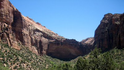
The Great Arch, seen from the east entrance road below the tunnel, Zion National Park. 


A spring running over the rock on the east road above the tunnel.

Kyle on rock near the road; the formations looked like they had been combed. 


A pretty pass above the tunnel

The Checkerboard Mesa overlook at the east entrance.  The formations look like they have been milled. 

  We left Utah on Wednesday, June 22, and drove to Barstow, CA, where we dry camped at a Flying J truckstop.  It was 48 degrees when we left Panguitch; 103 degrees in Barstow.  Ran the generator and A/C all night, surrounded by 100 idling diesel trucks.  Arrived at Orangeland RV Park in Orange, CA, (about 18 miles from Newport Beach and Michael) Thursday afternoon, June 23.


This is for Tom.  Yes it's a green egg from the Saturday morning farmers market in Orange.

Kyle getting an early start on his 21st birthday in Buca di Beppo Saturday night in Pasadena.  Saw Kevin Nealon (former SNL regular) at a comedy club there -- great show.


Walkway in Michael's condo complex -- it occupies a city block and has myriad walkways and  amenities.  Lots of flowers everywhere out here -- reminiscent of Hawaii.


Pool and flowers at Michael's place.


Kyle contemplating new sunglasses Sunday in PopKiller clothing store.


Yeah, Roasted Crabs.  From Mitsuwa Marketplace (think Japanese Walmart or maybe Target)


Sweet, crunchy, (very,very crunchy), chewy, one time treat


Excellent guitar duo at the every Tuesday night Huntington Beach street fair.


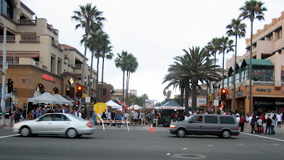
Main Street crowd at the HB street fair


The pier at Huntington Beach


Beach to west of pier; cool enough for a jacket


"Surf Capital of the U.S." -- preparing for the national championships in late July; east side of the pier


This guy had several nice rides -- note the wetsuit.  Water is cold, probably low 60's.

Michael's friend and former roommate Chad, with his girlfriend Jessica, and Michael and Kyle on the HB pier.


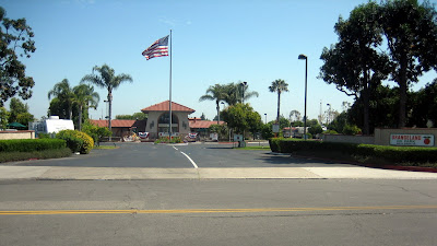
Entrance to Orangeland RV Park -- family owned and operated since 1972.  It was an orange grove before that.

Main building with office, pool, putting green, etc

Back of the main building with meeting rooms, offices, shower rooms


Our unit on Lot 199 (of about 210).  All paved.  Tight but nice, clean, well-kept


A little bit of grass and citrus trees

Lots of flowers -- trees and grounds are watered and maintained.


Note the oranges on the trees

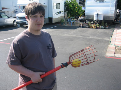
They provide fruit pickers to pick your own citrus; here I'm after grapefruit


Kyle with a large lemon from a tree adjacent to our lot


The fruit we picked and washed Wednesday -- grapefruit, lemon, navel orange, and two valencia oranges -- really juicy and sweet.
 
I had hoped to update the blog thru Wednesday night, July 6, but Blogger (or Picasa or something) would only let me upload a limited number of pictures.  Hopefully we'll get the rest up in the next few days.

We'll stay at Orangeland through Thursday, July 7, then head for Las Vegas for Kyle's 21st birthday on Friday, July 8.  Plan to head east Sunday, July 10 to be back in Morgantown Friday, July 15.

Posted by Picasa

Wednesday, June 22, 2011

Mossy Cave Trail

 Sunday, June 19:

Happy Birthday Tom!!

Today did not start well.  It rained until about 3 pm so we visited the rock shop and Indian store nearby, checked a few things on the RV, and caught up the blog.  Unfortunately, after proofreading and making the last correction on the blog, we lost the whole thing.  No doubt it was operator error, but it was still gone.  So it was a good time to go outside and do something else, rain or not.

We drove down the east side of the park to Tropic, Utah and checked it out.  Several B&B's, a service station, a couple motels and restaurants.  We filled up the car and went into the store:  we were surprised that it was a small supermarket and quite busy with several clerks.  All the other customers were foreign.  It's a farming valley with a healthy tourist business, apparently.  A very apropos sign read:  Behind Every Good Rancher is a Wife Who Works in Town.   

 
 Hoodoos along the Mossy Cave Trail
DOUBLE CLICK TO ENLARGE PICTURES

Along the northeast corner of the park is the only trail that does not originate on the rim road -- the Mossy Cave Trail.  Very, very nice.  It's a short trail, only about half a mile in with about 200 feet of rise.  Several people of moderate curiosity and hiking abilities were on the trail.  Mossy Cave itself is not much at this time of year; I've seen good photos of it with icicles in the wintertime.  It's not a cave but an overhang shelter carved out by springs; damp and mossy in the summer.   


Waterfall on the right fork of the Mossy Creek trail

The right fork goes further up the canyon -- Water Canyon -- to a falls and beyond.  Nice walking trail where you can venture onto the rocks and slopes as you wish and investigate the various sights.  There is something rejuvenating about getting off the graded and gravelled trails and moving through rougher, steeper terrain to see things. 


Primrose along the trail


Kyle above waterfall with windows in background

Upstream from waterfall


The stream here is not a natural flow.  It is part of the Tropic Ditch, a diversion ditch dug by Mormon settlers in the 1890's to direct flow from the East Fork of the Sevier River, across the plateau (now Bryce Canyon NP), down Water Canyon to the town of Tropic for irrigation.  With exception of one year of severe drought, it has flowed for 120 years.  The stream is only about 4 feet wide, but 2 to 3 feet deep and extremely fast.


Beuatiful tulip sized wildflower


Rick at windows
 

Largest window above waterfall

Looking at adjacent hoodoos through window

Formations to right of window


The park literature emphasizes how rapidly the hoodoos change and deteriorate.  Up close, they seem  like a mixture of various rocks in a shaly matrix -- I think I could dig into it with bare hands.  There is lots of evidence of very recent (this year) collapses and sloughings.  Be interesting to see what these windows look like in 5 years.
  

View of Kyle near waterfall from window rocks

Chatting with a more serious hiker from Washington, DC

Two fellows from DC hiked up to the window area while I was there.  They have been to Bryce and Zion numerous times and do quite a bit of day hiking and photography.  I knew they were pretty confident hikers when they crossed the stream on a log right at the top of the waterfall -- "just don't look down" he advised.  I went a quarter mile upstream where I could jump across.
 

Kyle on rock below waterfall


Formations in Red Canyon near RV park


Monday we're going to drive to Zion National Park from here and return.  It's supposed to be about one hour each way.


Tuesday, June 21, 2011

Hell of a Place to Lose a Cow

Friday, June17:

We left hot, semi-arid Moab and headed west on I-70 to the canyons of southwest Utah.  Passed over a lot of high, desolate, but beautiful country including Black Dragon Canyon and Ghost Rock into pine covered hills and farmlands.  The terrain varied from cliffs, towers, and mountains, to wide plateaus and valleys.  All striking and beautiful. 

The streams along the way are all running full from snow melt but the ground is dry enough to require irrigation.


Exiting I-70 south of Richlands, Utah.
DOUBLE CLICK ON PHOTOS TO ENLARGE

We made our usual twice a week stop at Walmart in Richlands to restock, fuel up, and head south on US 89.  We travelled south nearly 80 miles in the same wide agricultural valley (Central Valley?) along the Sevier River.  Passed through Circleville, the birthplace of Butch Cassidy.


Looking west across farmland near Circleville, UT, about 40 miles north of Bryce Canyon on US 89.


Our campground near Red Canyon area of Dixie National Forest
 We picked the Red Canyon RV Park from the Woodall's book because it was the closest we could get into on the west side of Bryce Canyon NP.  Four or five small commercial campgrounds and a couple federal in the vicinity.  Campground has good facilities, good location, and nice people.  Very laid back.  It's at about 7700 ft elevation so its cool -- highs in the 60's and 70's instead of the 90's of Moab.  Got down to 41 degrees the first night; had to get the little electric heater back out.


Looking at Rainbow Point, south end of park

Saturday, June 18:

Bryce Canyon NP is not really a canyon; it's a cliff face running north-south for 20+ miles. There's only one entrance, at the north end, and the rim road that runs the length of the park dead ends at the south end at 9100 feet elevation. The views are spectacular.  Park rangers say you can see 200 miles to the east on a clear day.
 

Near Black Birch Canyon, Bryce Canyon National Park
 
Arch and spires at Natural Bridge overlook 

Hoodoos at Ponderosa Canyon
 Due to the geology and climate, the soft rock gets frost wedged or eroded into all kinds of strange shapes and figures of varying colors.Many of the "hoodoos" look like they escaped from Easter Island.  The Indians refer to them as "Legend People".


Ponderosa Canyon

Small group of hoodoos on ledge at Paria View

Virtually all of the visitors are driving (or bussing) from one overlook to another along the rim road.  Most of the visitors are European -- primarily Germans along with a few Italians and French.

Only a few hearty souls descend the steep trails into the valleys and muster the energy for the return climb. 

Cathedrals at Bryce Point Overlook

The cathedrals and windows are formed by springs in the cliff face eroding out holes or caverns.  Later, as that face separates from the bank, these holes become windows or arches.


Wildlife

Ranks of hoodoos in Bryce Canyon ampitheatre


Purportedly, Ebenezer Bryce, a Mormon, who owned Bryce's Canyon in the 1870's, was asked by a reporter what he thought of the canyon.  Bryce said, matter of factly, "Hell of a place to lose a cow".  I agree. Don't know how true that report is, but I'm sure the sentiment is about right.  Not much of value to a struggling homesteader, but it is a very unique and beautiful place.  I give Yellowstone higher marks, due to its many and varied points of interest, but for shear natural beauty, we've not seen anything that tops Bryce Canyon.


Inspiration Point

Kyle near Inspiration Point
 Bryce Canyon NP is in the middle of nowhere.  There are no towns within 50 miles that anyone has heard of.  Most of the campgrounds, motels, and restaurants are all locally owned.  We stopped at the Bryce Canyon Pines restaurant (with attached motel, RV park, and store) I think because they advertised homemade soup and pie.  Great boysenberry pie.  It is a family venture started in 1956 and doing a land office business.  (We had tried to camp there -- very pretty -- but they were full).

Staying in this area a few more days to see the sights, tend to the RV, catch up the blog, and kick back.